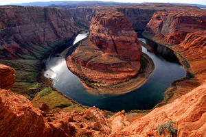
Having traveled extensively with her family across the Colorado River Paulette Dotson loves learning about its long, interesting history and impact within the United States.
The Colorado river was the last major river in America to be fully explored and mapped but as soon as John Wesley Powell made his historic decent in 1869 it was promoted, becoming the key to the West’s development and a life giving tool as it irrigated acres of land and sustained great cities. The river drains watersheds from seven Western states which are then divided into two districts. The Upper Basin is comprised of Colorado, New Mexico, Utah and Wyoming while the Lower Basin is formed by Arizona, California and Nevada. The headwaters are situated in Wyoming and Colorado and its mouth flows into the Gulf of California.
The Colorado River courses south westerly through the state of Utah and has two major tributaries: the Green and San Juan rivers. In the times before colonization, it acted as a boundary between the southern and eastern Anasazi population and both the Fremont and western Anasazi populations. These Indians created a system of trails which were later used by Spanish and Anglo-American explorers as they travelled and settled. Historically, Native American groups have always lived alongside the river, creating rich bodies of lore around the body of river. The Spaniards provided the first documented information about the river, giving it names like El Rio de Cosninas or Rio de Tizon. It was the missionaries who in the eighteenth century chiseled steps and smoothed the path so livestock could travel through. In the 1820s and 1830s, European-American mountain men ventured into the area, searching for a beaver along the banks and leaving their inscriptions in the canyons.
It was not until 1869 that the Colorado river was fully mapped. The Smithsonian institute and Congress sponsored John Wesley Powell’s trips to chart the water’s course. His ten man crews collected information as they sailed their wooden boats down the waterways. After that many people came to cross or visit the Colorado River. In 1880, Mormons built the Hole in the Rock trail and Charles Hall, a year later, placed a thirty foot ferry boat on the crossing (it closed down after three years). Miners with golden dreams lived alongside it in the 1890s, some dredging the water for riches. The 1930s and 1940s saw the river turn to profit. Norman Nevills sold the river as a recreational vacation spot, selling the idea of a white water and red rock adventure. Colorado remains a playground for kayakers, rafters and tourists like Paulette Dotson and her family.
Throughout the late 19th and early 20th centuries, the rise of water reclamation led to the construction of the Hoover Dam and the distribution of Colorado’s water amongst seven states. Nowadays it provides 40 million people with water and irrigates cropland that is the source of 15% of the country’s food. Many people forget that this river is a desert river and the annual demand for water is 1.4 trillion gallons overestimated. There are current calls to look into the sustainability on relying on the Colorado River for water supplies.